
Freunden von diesem Artikel berichten:
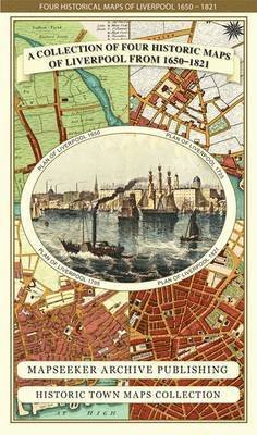
Liverpool 1650 to 1821 - Fold Up Map Containing Town Plans of Liverpool that include Liverpool 1650, 1725, 1795 and Sherwood's plan of Liverpool and Environs 1821 - Liverpool Historic Maps Collection
Mapseeker Publishing Ltd.
Preis
Fr. 23,49
Bestellware
Lieferdatum: ca. 14. - 21. Jun

Zu deiner iMusic Wunschliste hinzufügen
Liverpool 1650 to 1821 - Fold Up Map Containing Town Plans of Liverpool that include Liverpool 1650, 1725, 1795 and Sherwood's plan of Liverpool and Environs 1821 - Liverpool Historic Maps Collection
Mapseeker Publishing Ltd.
This folded map (890mm 1000mm when unfolded) is an ideal souvenir for tourists to Liverpool and also a valuable reference resource for local and family history research. The larger Plan of Liverpool from 1824 is by Sherwood, reproduced in full colour for the first time working from the rare antique original.
1 pages
| Medien | Bücher Landkarten (Land- oder Seekarten) |
| Erscheinungsdatum | 25. September 2014 |
| ISBN13 | 9781844918232 |
| Verlag | Historical Images Ltd |
| Seitenanzahl | 1 |
| Maße | 228 × 139 × 38 mm · 108 g |
Alle anzeigen
Weitere Titel von Mapseeker Publishing Ltd.


Alle Titel von Mapseeker Publishing Ltd. ansehen ( u. a. Landkarten und Taschenbuch )