

Freunden von diesem Artikel berichten:
Rand McNally Folded Map: Los Angeles Street Map
Rand McNally

Rand McNally Folded Map: Los Angeles Street Map
Rand McNally
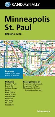
Rand McNally's folded map for Los Angeles is a must-have for anyone traveling in and around this part of California, offering unbeatable accuracy and reliability at a great price. Our trusted cartography shows all Interstate, U. S., state, and county highways, along with clearly indicated parks, points of interest, airports, county boundaries, and streets. The easy-to-use legend and detailed index make for quick and easy location of destinations. You'll see why Rand McNally folded maps have been the trusted standard for years. -Regularly updated. -Full-color maps. -Clearly labeled Interstate, U. S., state, and county highways. -Indications of parks, points of interest, airports, county boundaries, schools, shopping malls, downtown & vicinity maps. -Easy-to-use legend. -Detailed index & full street index. -Convenient folded size. Coverage Area: Communities included, Bel Air Estates, Beverly Hills, Brentwood, Culver City, Hollywood, Huntington Park, Inglewood, Malibu, Mar Vista, Pacific Palisades, Santa Monica, Venice, West Hollywood. Product Details: Measures 9.5' x 4' and folds out to 40' x 28'.
| Medien | Bücher Taschenbuch (Buch mit Softcover und geklebtem Rücken) |
| Erscheinungsdatum | 12. August 2021 |
| ISBN13 | 9780528024382 |
| Verlag | Rand McNally |
| Maße | 107 × 224 × 13 mm · 250 g (Geschätztes Gewicht) |
| Sprache | Englisch |
Weitere Titel von Rand McNally


Andere haben auch gekauft
![Cover for Preben Hansen · Turen Går Til: Turen går til Californien & Vestlige USA (Taschenbuch) [5. Ausgabe] (2021)](https://imusic.b-cdn.net/images/item/original/578/9788740063578.jpg?preben-hansen-2021-turen-gaar-til-turen-gaar-til-californien-vestlige-usa-taschenbuch&class=scaled&v=1623395637)
![Cover for J. K. Rowling · Harry Potter: Harry Potter 6 - Harry Potter og Halvblodsprinsen (Gebundesens Buch) [5. Ausgabe] (2015)](https://imusic.b-cdn.net/images/item/original/277/9788702173277.jpg?j-k-rowling-2015-harry-potter-harry-potter-6-harry-potter-og-halvblodsprinsen-gebundesens-buch&class=scaled&v=1441302687)
![Cover for Olga Ravn · De ansatte (Taschenbuch) [1. Ausgabe] (2018)](https://imusic.b-cdn.net/images/item/original/583/9788702265583.jpg?olga-ravn-2018-de-ansatte-taschenbuch&class=scaled&v=1521711504)
![Cover for Paludans Bilatlas over Europa 2016 (Spiralbuch) [1. Ausgabe] (2016)](https://imusic.b-cdn.net/images/item/original/473/9788772307473.jpg?2016-paludans-bilatlas-over-europa-2016-spiralbuch&class=scaled&v=1532297840)
![Cover for Betty Edwards · Drawing on the Right Side of the Brain: A Course in Enhancing Creativity and Artistic Confidence: definitive 4th edition (Gebundenes Buch) [Main edition] (2013)](https://imusic.b-cdn.net/images/item/original/778/9780285641778.jpg?betty-edwards-2013-drawing-on-the-right-side-of-the-brain-a-course-in-enhancing-creativity-and-artistic-confidence-definitive-4th-edition-gebundenes-buch&class=scaled&v=1398870041)

![Cover for Kent Haruf · Eventide - Plainsong (Taschenbuch) [Main Market Ed. edition] (2013)](https://imusic.b-cdn.net/images/item/original/457/9781447240457.jpg?kent-haruf-2013-eventide-plainsong-taschenbuch&class=scaled&v=1396360108)


![Cover for Barbara Kingsolver · Demon Copperhead: Winner of the Women's Prize for Fiction (Taschenbuch) [Main - Re-issue edition] (2023)](https://imusic.b-cdn.net/images/item/original/483/9780571376483.jpg?barbara-kingsolver-2023-demon-copperhead-winner-of-the-women-s-prize-for-fiction-taschenbuch&class=scaled&v=1680172538)
![Cover for Disney · Carl Barks & Don Rosa Bind II (Gebundenes Buch) [1. Ausgabe] (2020)](https://imusic.b-cdn.net/images/item/original/218/9788793840218.jpg?disney-2020-carl-barks-don-rosa-bind-ii-gebundenes-buch&class=scaled&v=1596799987)
Alle Titel von Rand McNally ansehen ( u. a. Taschenbuch , Landkarten , Gebundenes Buch , Buch und Spiralbuch )